
Woke up to the sound of the howling wind at my hotel window. Where was I? After sleeping in a different place each night for the past six nights ... it was getting hard to remember.

Oh yah, Tombstone.
We were staying at the Holiday Inn Express, Tombstone, located just North of the Tombstone main street.
It was located on a small bluff -- thus the wipping wind at night. There were beautiful views of the mountains out the breakfast window. (Click on any image to see it BIGGER)
The night before, we had visited the old Boothill Graveyard and the Tombstone Main Street.

 This morning we went by the Courthouse for a visit, but it wasn't open yet.
Then we went over to the site for the SASS shooting event.
We met some guys from the local club who were setting stuff up. This shoot is know for it's close range targets, and they certainly were only a few feet away (not tens or a hundred feet away).


Tombstone Tuesday, October 20, 2009
Road Trip: day four Monday, October 19, 2009
Odessa, TX to Tombstone, AZLeft Odessa at 801am. 56 degrees and sunny.
The air was filled with the smell of oil and to the North and South of the freeway we could see oil pumps and towers.
Pretty soon after that we could see mountains in the distance and the name of our highway became Texas Mountain Trail. (The region is highlighted on the map of Texas.)

Went through the Apache, then the Sierra Blanca Mountains.
"West of the highway are the Sierra Diablo Mountains. many are above a mile high; Victorio Peak (10) reaches 6,350 feet. Sears in red sandstone formations on the mountains’ flanks mark sites of man’s effort to extract silver and copper ore. Much of the Sierra Diablos is a state wildlife management area. Hidden in the Sierra Diablos is Victorio Canyon, site of one of the last great Indian Battles in Texas. Indian burial grounds and pictographs are found there, but the area is not accessible to the public."[link]
Arrived on the edge of El Paso around 11am. At one point, my cell phone switched over to the Mexican cellular service since I-10 runs right along the border. It was 81 degrees and sunny in El Paso.
How could we pass up the Stateline for lunch? Pulled in right at 11:30 when they were opening. Mmm, mmm, BBQ.
Crossed into New Mexico after lunch around 12:45 and headed toward Las Cruces. I was saddened to drive right by and not be able to stop and visit!
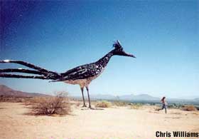
At the West end of LC on the 10, there's a giant metal sculpture of a roadrunner up on a small cliff overlooking the highway. According to the roadsideamerica.com website, it was made from recycled trash and installed around 2000.
We continued along the 10 W and pulled out in Deming to gas up and take a break.

 Crossed the border and into Arizona time (aka sometimes PT and sometimes MT) into Arizona around 4pm.
Few good clouds with rain coming down but couldn't see if the rain made it to the ground.
 A while later, we passed through the Texas Canyon (in Arizona) about 20 miles east of Benson/Tucson.
Finally, around 5pm, we turned off I-10 south onto Arizona 80 toward Tombstone. Route today: I-20 to I-10 to Arizona 80S for 581 miles. Get the scoop - read on!
Road trip: day three Sunday, October 18, 2009
Texarkana, Texas to Odessa, Texas
Took off from Texarkana at 815am today. It was sunny and 39 degrees. We observed high water levels in the rivers in this area due to rain. While the weather and roads were clear, we did pass through some curious spots of heavy fog. We weren’t sure of the source - Maybe from the lake nearby.
A few cattle ranches started to pop up as well as ranches for pretty spotted ponies (aka Palominos) and other horses. Not much traffic. The trees thinned out and started to look more like Scrub Oak and Juniper.
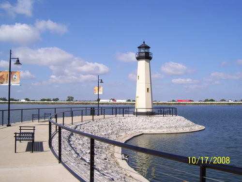
Passed next to and over the Rockwall Reservoir (I-30 traffic in the background of the lighthouse on the Reservoir shown in the photo) just outside Dallas. With the Sun sparkling on the water, it looked like a great day for Bass fishing and leisurely boating.
Went through the Dallas (skyline shown in the photo) mixing bowl and on to Ft. Worth to pick up Interstate 20. West of Ft. Worth was hill country with scrub oaks, mesquite, and prickly pear cactus. Long horns too.

The scenario was that of the Texas Hill Country in Autumn. Lovely rolling hills, with great vistas out over the oaks and surrounding landscape.
Don't need long sleeves and jackets any more. Saw first oil pumper.
West of Eastland, the wind kicked up. Saw several windmill farms with cotton plants growing in the surrounding fields as shown in the photo. The biggest being at Roscoe, TX largest in the nation and world. (NPR Story)

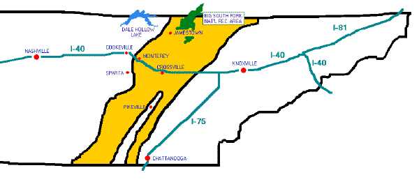
The first oil well in this area was drilled in 1920 is near where we passed on I-20 in the Permian Basin near Odessa (the home of George W. and Laura Bush at one time). The locations of Odessa and the Permian Basin are shown the on this map.
The Permian Basin "{} is so named because it has one of the world's thickest deposits of rocks from the Permian geologic period". [Wikipedia, Permian Basin (North America)]

Temperature was going up in the late afternoon and the vegetation shrinking and thinning out. Now 81 degrees.
Route today: I-30 and I-20 for 530 miles. Get the scoop - read on!
Road trip: day two Saturday, October 17, 2009
 We left Dickson, Tennessee at 8:05 am. It was about 43 degrees and cloudy. Lots of trucks on Hwy 40 at this hour on a Saturday. Tall and thick forest lined both sides of the road just as it had in Virginia. We crossed the edge of Kentucky Lake early in the day. Looked to be the most narrow part here. Sun and blue sky in every direction - finally. Saw our first cotton fields. The trees were mostly green today as more and more were evergreen opposed to deciduous.

Stopped in Memphis at 1030am – first time visit for HEZ.  Went first by the Lorraine Hotel (now the National Civil
  Rights Museum)
  where Martin Luther King was shot ... then downtown by FedEx stadium and then Mud Island River Park on the Mississippi River via a monorail from the main land. Pretty chilly outside (high 40s) and people were commenting on that. Visited not only a steamboat but a monitor as well! Here is a video of the Island.
Here is a photo and a video of the scale Mississippi River at the museum.
Got back on the road around 1:30pm. Saw two instances of 18 wheelers that had crashed by jumping through the grass median and getting perpendicular with the other side of the freeway. - Very scary.
Passed through the rice fields of East Arkansas. This is a new state for HEZ. Saw the capitol building of Arkansas in Little Rock at 3:30pm.  Then turned onto the Hwy 30 and south toward Texarkana.
Crossed the border between Arkansas and Texas at 6pm.
Route today: Interstate 40 to Interstate 30 for a total of 450 miles today.
Road trip: day one Friday, October 16, 2009
Charlottesville, Virginia to a TBD location in Tennessee
Up at 7 am. Packed the van and headed out at 8:30 am. Temperature 44 degrees, cloudy but no rain. Light traffic in the C'ville area; school is in session.

We were treated to lots of colorful fall trees, green fields, and rolling hills. The most colorful trees, with bright reds and orange leaves, looked to be on fire to me! We passed a few corn and tobacco fields and saw cows, horses, and alpacas. The usual fog was hanging around at Staunton. The grassy highway medians filled with blooming pink wild flowers.

Saw the signs that indicated we were on the Civil War Trail but didn't have time to stop at any of the sites.

Interstate 40 is called the “Music Highway” in Tennesse from Nashville, the unofficial birthplace of Country Music, to Memphis, birthplace of the Blues.
Hwy 40 turned into a parking lot at the western edge of Nashville due to an accident. We turned south on the 440 then caught the 70S to get around the jam. This alternate route took us through some fantastic old neighborhoods in the West End area of Nashville.
As the sun light grew dim, the 40 seemed to narrow as we found ourselves surrounded by 18 wheeler trucks making for a kind of “trucks” rule the road scenario. As we moved away from the city, the traffic thinned out and we decided to call it a day at Dickson, TN. We had hoped to make it as far as Jackson, TN but that was another 100 miles West and it was already 7:30 pm.
Ate dinner at a local Tennessee cafeteria-style restaurant, Farmer's Family Restaurant, complete with live music. We snacked on fresh, delicious corn bread, sweet with corn kernels, each in the shape of a small pancake. (Somehow we missed the gator and frogs legs!)
Route today: 29 to 64 to 81 to 40 for a total of 630 miles.
Road trip: day zero Thursday, October 15, 2009
Los Angeles to Central VirginiaI’m preparing for a cross country road trip from Virginia to Arizona via four days of driving. The temperature range for our journey is predicated to be from the high 30s to the low 90s.
via Cleveland and Richmond

Our planned route will take us from Virginia to Tennessee, then Arkansas, then from Texarkana to El Paso, Texas, and finally southern New Mexico and Arizona. The total route is predicted to be approximately 2500 miles.
Flying on Continental for the first time in many years … Found out that Continental has a web site continental.com/info that shows real-time info on plane status (seats filled or not) as well as info on where the plane is coming from with arrival and departure times.
Have my web-enabled device with me – so I’m ready to hit the road! Get the scoop - read on!