
Odessa, TX to Tombstone, AZLeft Odessa at 801am. 56 degrees and sunny.
The air was filled with the smell of oil and to the North and South of the freeway we could see oil pumps and towers.
Pretty soon after that we could see mountains in the distance and the name of our highway became Texas Mountain Trail. (The region is highlighted on the map of Texas.)

Went through the Apache, then the Sierra Blanca Mountains.
"West of the highway are the Sierra Diablo Mountains. many are above a mile high; Victorio Peak (10) reaches 6,350 feet. Sears in red sandstone formations on the mountains’ flanks mark sites of man’s effort to extract silver and copper ore. Much of the Sierra Diablos is a state wildlife management area. Hidden in the Sierra Diablos is Victorio Canyon, site of one of the last great Indian Battles in Texas. Indian burial grounds and pictographs are found there, but the area is not accessible to the public."[link]
Arrived on the edge of El Paso around 11am. At one point, my cell phone switched over to the Mexican cellular service since I-10 runs right along the border. It was 81 degrees and sunny in El Paso.
How could we pass up the Stateline for lunch? Pulled in right at 11:30 when they were opening. Mmm, mmm, BBQ.
Crossed into New Mexico after lunch around 12:45 and headed toward Las Cruces. I was saddened to drive right by and not be able to stop and visit!
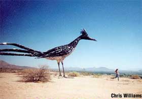
At the West end of LC on the 10, there's a giant metal sculpture of a roadrunner up on a small cliff overlooking the highway. According to the roadsideamerica.com website, it was made from recycled trash and installed around 2000.
We continued along the 10 W and pulled out in Deming to gas up and take a break.

 Crossed the border and into Arizona time (aka sometimes PT and sometimes MT) into Arizona around 4pm.
Few good clouds with rain coming down but couldn't see if the rain made it to the ground.
 A while later, we passed through the Texas Canyon (in Arizona) about 20 miles east of Benson/Tucson.
Finally, around 5pm, we turned off I-10 south onto Arizona 80 toward Tombstone. Route today: I-20 to I-10 to Arizona 80S for 581 miles.
0 comments:
Post a Comment